Pothohar Plateau
(سطح مرتفع پوٹھوہار)
The geographical boundary of the region Pothohar in the Indus River delta is from Jhelum to Attock. This region has an area of 12,944 square kilometers.
The seasonal streams have divided this area into small and large ups and downs. By merging these watercourses, the famous river of this area Soan came into being.
Traces of millions of years old human civilization have been discovered on the river Soan bank.
In March 1976, the archaeological department of Pakistan in collaboration with the experts of an American university discovered a human jaw. According to the research report, this jaw is millions of years old.
The supervisor of the American Research team, Sir David Hill claimed that humans were living there about 20 million years ago.
This area is rich in minerals like natural gas, mineral oils, salt, gypsum, limestone, silica sand, and lots of others.
Key Info about Potohar Plateau
| Aspect | Details |
|---|---|
| Name | Potohar Plateau |
| Location | Northern Pakistan, extending into parts of Punjab, Khyber Pakhtunkhwa |
| Geographical Area | Varies, covering parts of Punjab, Khyber Pakhtunkhwa, and Azad Kashmir |
| Elevation | Ranges from approximately 305 meters (1,000 feet) to 610 meters (2,000 feet) above sea level |
| Climate | Typically experiences a subtropical climate with hot summers and cool winters |
| Vegetation | Diverse, includes shrubs, grasses, and some tree species |
| Geological Features | Comprises sedimentary rock formations, including limestone and sandstone |
| Cultural Significance | Historically rich with archaeological sites, including Taxila, a UNESCO World Heritage Site |
| Economic Activities | Primarily agricultural, with cultivation of crops such as wheat, barley, and millet |
| Land Use | Utilized for agriculture, settlements, and some areas reserved for conservation |
| Wildlife | Supports a variety of wildlife, including birds, reptiles, and small mammals |
| Water Resources | Limited natural water resources, with reliance on rivers and reservoirs for irrigation |
| Tourist Attractions | Taxila, historical sites, and the scenic landscape attract tourists interested in archaeology and nature |
| Challenges | Erosion and deforestation are environmental concerns, and water scarcity poses challenges to agriculture |
| Cultural Heritage | Home to ancient civilizations, contributing to the region’s cultural richness |
Exploring the Rich Tapestry of Potohar Plateau
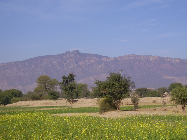
Nestled in the northern regions of Pakistan, the Potohar Plateau emerges as a captivating expanse, weaving together a tapestry of cultural heritage and diverse landscapes. Stretching across parts of Punjab, Khyber Pakhtunkhwa, and Azad Kashmir, this elevated plateau not only stands as a geological marvel but also bears witness to the footsteps of ancient civilizations.
Geographical Features
The Potohar Plateau, characterized by its undulating terrain, unfolds between the majestic Margalla Hills and the mighty Jhelum River. Elevations vary, ranging from approximately 305 meters (1,000 feet) to 610 meters (2,000 feet) above sea level. The landscape, dominated by sedimentary rock formations like limestone and sandstone, offers a visual spectacle.
Climate and Vegetation
The plateau experiences a subtropical climate, marked by hot summers and cool winters. Vegetation is diverse, comprising shrubs, grasses, and select tree species adapted to the arid conditions. The landscape undergoes a transformation with the changing seasons, each bringing its own hues to the palette.
Cultural Significance
Potohar Plateau is steeped in history, and its cultural significance is exemplified by the presence of Taxila, an archaeological treasure trove. Taxila, a UNESCO World Heritage Site, bears witness to the Gandhara civilization and stands as a testament to the region’s pivotal role in ancient trade routes and cultural exchange.
Economic Activities
Primarily an agricultural region, the plateau sustains livelihoods through the cultivation of crops such as wheat, barley, and millet. Its strategic location has historically made it a crossroads for trade and commerce, contributing to its economic vibrancy.
Wildlife and Natural Resources
Despite its arid nature, the plateau supports a variety of wildlife, including birds, reptiles, and small mammals. Natural resources are a mix of limited water bodies and reservoirs, forming the lifeline for agricultural activities.
Tourist Attractions
Beyond its historical sites, Potohar Plateau attracts tourists with its scenic landscapes and natural beauty. The Margalla Hills National Park provides a sanctuary for nature lovers, and the ancient ruins of Taxila beckon archaeology enthusiasts from around the globe.
Famous Places in Potohar Plateau
Taxila – UNESCO World Heritage Site
Renowned as one of the most important archaeological sites in South Asia, Taxila takes pride of place on the Potohar Plateau. A UNESCO World Heritage Site, it showcases the remnants of the Gandhara civilization, including well-preserved stupas, monasteries, and statues. The Taxila Museum adds another layer to the historical narrative, housing artifacts that date back thousands of years.
Margalla Hills National Park
Nestled on the northern edge of the Potohar Plateau, the Margalla Hills National Park is a haven for nature enthusiasts. The park offers panoramic views, hiking trails, and a rich biodiversity, providing a refreshing escape from urban life. Diverse flora and fauna, coupled with well-maintained hiking paths, make it a popular destination for locals and tourists alike.
Rawat Fort
Perched on a strategic location overlooking the Potohar Plateau, Rawat Fort is a historical gem. Dating back to the 16th century, the fort stands as a testament to the military architecture of the Mughal era. Its commanding position offers breathtaking views of the surrounding landscape.
Khanpur Dam
A tranquil oasis amidst the rugged terrain, Khanpur Dam is a picturesque destination that attracts nature lovers and adventure seekers. The dam, surrounded by hills, offers opportunities for boating, fishing, and hiking. The serene waters against the backdrop of the Margalla Hills create a mesmerizing setting.
Pharwala Fort
Situated near the Jhelum River, Pharwala Fort is an ancient structure with roots dating back to the 11th century. The fort’s architecture is a blend of Hindu and Muslim influences, reflecting the diverse history of the region. The scenic beauty around the fort adds to its allure.
Rohtas Fort
Located near Jhelum, Rohtas Fort is a UNESCO World Heritage Site that commands attention with its grandeur. Built by Sher Shah Suri in the 16th century, the fort served as a defensive bastion. Its massive walls, gates, and architectural features make it a captivating destination for history enthusiasts.
Kalar Kahar
Known for its stunning saltwater lake and lush surroundings, Kalar Kahar is a popular stopover for travelers. The lake, set against a backdrop of hills, provides a serene setting for relaxation. The nearby Katas Raj Temples, a collection of ancient Hindu temples, add cultural significance to the area.
Wah Gardens
Wah Gardens, also known as Wah Cantt Gardens, offer a peaceful retreat with well-maintained lawns, fountains, and vibrant flower beds. The gardens are a favored spot for locals to unwind and enjoy nature’s beauty.
Jalalpur Sharif
A town with historical and religious significance, Jalalpur Sharif is home to the shrine of Hazrat Shah Shams Tabrez. The shrine attracts devotees and visitors seeking spiritual solace.
Frequently Asked Questions (FAQs)
What is the Potohar Plateau?
Potohar Plateau is a geographical region in northern Pakistan, extending into parts of Punjab, Khyber Pakhtunkhwa, and Azad Kashmir. It is characterized by undulating terrain, diverse landscapes, and historical significance.
What is the significance of Taxila in the Potohar Plateau?
Taxila, a UNESCO World Heritage Site in the Potohar Plateau, is an ancient archaeological site with remnants of the Gandhara civilization. It holds historical and cultural importance, showcasing Buddhist stupas, monasteries, and artifacts.
What is the climate of the Potohar Plateau like?
The Potohar Plateau experiences a subtropical climate with hot summers and cool winters. The region’s elevation and terrain contribute to variations in temperature and weather patterns.
Are there any famous landmarks in the Potohar Plateau?
Yes, notable landmarks include Taxila, Margalla Hills National Park, Rawat Fort, Khanpur Dam, Pharwala Fort, Rohtas Fort, and various historical sites reflecting the region’s rich heritage.
What economic activities are prevalent in the Potohar Plateau?
Primarily an agricultural region, the plateau supports the cultivation of crops such as wheat, barley, and millet. Additionally, it has historical significance for trade and commerce.
Is the Potohar Plateau known for its natural beauty?
Yes, the Potohar Plateau is known for its scenic landscapes, including the Margalla Hills, lakes like Khanpur Dam, and lush surroundings. These areas attract nature enthusiasts and tourists.
What challenges does the Potohar Plateau face?
Erosion, deforestation, and water scarcity are environmental challenges in the region. Balancing conservation efforts with agricultural practices is essential for sustainable development.
Are there recreational areas in the Potohar Plateau?
Yes, recreational areas like Margalla Hills National Park offer opportunities for hiking, birdwatching, and enjoying nature. The region provides a peaceful retreat for locals and tourists.
What is the cultural significance of the Potohar Plateau?
The Potohar Plateau has a rich cultural heritage, with historical sites dating back to ancient civilizations. It reflects influences from various periods, including the Gandhara civilization.
Are there any religious or spiritual sites in the Potohar Plateau?
Yes, the region is home to shrines and historical religious sites, including those associated with Sufi saints. These sites attract pilgrims and visitors seeking spiritual experiences.
How can one explore the Potohar Plateau?
Exploring the Potohar Plateau can be done by visiting historical landmarks, nature reserves, and cultural sites. Hiring local guides or joining organized tours enhances the experience.
Wind Up Lines
Potohar Plateau stands as a testament to the resilience of both nature and humanity. Its rolling landscapes, enriched by history and cultural significance, beckon explorers and scholars alike to delve into its mysteries. As conservation efforts harmonize with agricultural pursuits, the plateau continues to evolve, embodying the spirit of a region where heritage seamlessly intertwines with the timeless beauty of the land.