
A Revival of the Ancient Silk Route
8th Wonder of the World
Karakoram Highway is built by the mutual collaboration of the Islamic Republic of Pakistan and the People’s Republic of China. It connects China and Pakistan. Its construction started in 1966. About 24, 500 people took part in its construction.
| Aspect | Information |
|---|---|
| Name | Karakoram Highway (Silk Route) |
| Location | Connects China and Pakistan |
| Construction Start Year | 1966 |
| Construction Workers | Approximately 24,500 people |
| Construction Sacrifices | 892 lives lost during construction |
| Significance | Considered the 8th Wonder of the World |
| Collaboration | Constructed through collaboration between the Islamic Republic of Pakistan and the People’s Republic of China |
| Impact on Tourism | Boosted tourism in Pakistan, especially in the valleys along the route during the summer |
| Challenges | Harsh terrain, rugged rocks, high altitudes, and sometimes, harsh weather conditions affecting travel to Skardu and Gilgit |
| Access to Central Areas | Air-conditioned and non-air-conditioned buses, wagons, and coasters available from Pirwadhai General Bus Stand Rawalpindi |
| Prominent Locations | Chalas, Gilgit, Astore, Hunza, and Skardu |
| Air Travel to Skardu and Gilgit | PIA flights available, but subject to specific weather conditions |
| Start and End Points | Starts from Hassan Abdal, ends in Xinjiang province, China |
| Impact on Gilgit Baltistan | Key role in the region’s progress, providing business and employment opportunities, though impacting local culture |
| Terrain Description | Highway built by cutting rugged rocks, touching mountain peaks at some points, and embracing foothills at others |
Eight hundred and ninety-two people lost their lives during the construction of this World Wonder. It can be said that there is a sacrifice of one life for the construction of the one-kilometer road.
It is considered the eighth Wonder in the World which is completed by the teamwork of Pakistani Engineers (FWO) and Chinese Experts. It fascinates every tourist by twisting roads and beautiful scenery.
This highway is built by cutting rugged rocks. This highway touches the mountains’ peak at some points. While at the other places, it seems to move by embracing the foothills of sky-scraping mountains.

Karakoram highway was inaugurated formally by the Chief Martial Law Administrator General Zia-ul-Haq of Pakistan and a Chinese Minister at the point of Tahkot after its completion.
Before the Shahra-e-Resham, Babusar was the only track to reach these areas. This way is used to connect Mansehra, Bala Kot, Kaghan, Naran, Besal, and Babusar to Chalas. This route used to remain functional for four months a year. And it was blocked for the remaining year due to snowfall.
This highway has played a key role in the progress of Gilgit Baltistan but, it has affected the traditions, culture, norms, and conservatism of this region. People have gained opportunities for business and employment after the establishment of this highway.
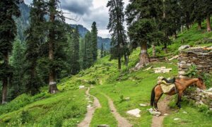
This highway has boosted tourism in Pakistan. The valleys in the suburbs of this highway are crowded with local and foreign tourists in the summer.
Air-conditioned and Non-Air- Conditioned buses, wagons, and costers are available for all the central areas of Gilgit Baltistan from Pirwadhai General Bus Stand Rawalpindi. In these central areas, Chalas, Gilgit, Astore, Hunza, and Skardu are more prominent. These all spots are linked to each other via roads. A four-wheeled jeep can be hired for visiting the valleys and different areas of these sites.
PIA flights are available for Skardu and Gilgit. But, it requires special weather conditions like atmospheric pressure to land in Gilgit and Skardu. Sometimes, the flights return back to Islamabad due to climate conditions.
Shahra-e-Resham or Karakoram Highway starts from Hassan Abdal at a distance of 48km on the Rawalpindi to Peshawar road. It passes through Abbottabad, Mansehra, Basham, Chalas, Hunza, Sust, and Khunjerab Pass. It enters China in the province of Xinjiang.

Places in the suburbs of Silk Route
1- Shiva Temple
This ancient historical temple is on the left side of Hathi Mera Chowk on the Gilgit Raod at a distance of 6km from Mansehra. It is called “Shiva Ji Ka Mandir”.
2- Bafa
It is the headquarter or capital of Hazara’s plain area Pikhal. Gali Bagh is a famous village in Baffa. It is the same place that was the capital of the Turk Government. The remains of historical buildings of that time are still there. Baffa is famous for a special dish called “Khawa”. It is prepared with pure milk.
3- Siran Valley
A jeep track goes to Jabori, Nadi, and Sharan (Kaghan Valley) along the river Siran near the Shinkiari. There is a forest rest house established in 1919 at a distance of 24 km from Jabori. It was damaged in the earthquake of 2005.
4- Shinkiari
Shinkiari has the meaning of a green garden. There is a junction of Shinkiari Konsh Valley, Siran Valley, and Bafa at a distance of 18km from Mansehra. This area is favorable for tea production because of its geography, climate, and natural environment. There are tea orchard research institutes too.
5-Shahzaib Lake
A route on the right side after crossing the Shinkiari border is directed to artificial Lake Shahzaib. It is located 5km from Karakoram Highway (Shahrah Resham), on Dadar Bhogar road near the bank of the river Siran. There are some restaurants and hotels for a stay near this beautiful lake. There are facilities for swimming and sailing. It is a peaceful and calm place since it is away from the main road.
6- Bit Gram and Cable Car
This area will provide you with facilities of every kind. This site has traces of Buddhism near the hills of Pishora. There is a cable car which is 12 km from Bit Gram Bazar on the Karakoram Highway. This cable car operates on a single wire to move across the river Nandi Har. It is a thrilling experience to travel on a single-wire cable car with a noisy river below. Stay here for refreshment.
7- Thakot

The river Indus flows along the Resham Highway till Thakot. From here, the rivers diverge. On the completion of the Karakoram Highway (Shahrah e Resham), Pakistan’s President General Zia-ul-Haq and the Chinese Minister were inaugurated at this site.
There is a different kinds of settlements beyond Thakot Bridge which are 77km from Mansehra. Their traditions, culture, and norms are quite different.
8- Bisham
It is about in the center of Rawalpindi and Gilgit at a distance of 28km from Thakot. Almost every vehicle stays here for a while. It is a crowded site in this area. You can make it your base camp for Alai. The beautiful valley Dabir is near this site. You can use this track to reach Swat the Switzerland of the East via Alpuri and Shangla Top.
9- Alai Valley
This district of Mansehra is known for Pakhtun Culture and hospitality. You can reach Thakot and Basham. This valley is enriched with lush green gardens and Deodar Cedar tree forests and has a pleasant cold in summer. It is better to wear warm clothes here. It is bitter cold in the valley from November to April. A jeep can be avail from Kund Bridge which is 2km from Basham. But, public transport is accessible from Thakot.
10- Basham to Sazin
The valleys of northern areas fenced by mountains seem to be the princesses imprisoned by giants. The region from Basham to Sazin is blessed with natural beauty. The human intellect is astounded by the roaring river Indus between luxuriant green sky kissing mountains, an abundance of evergreen trees on both sides of the river, an excess of clear cascades and waterfalls, singing, dancing, and murmuring water channels.
But unfortunately, the tourists miss nature’s masterpieces and splendid landscapes due to the long distance between Rawalpindi to Gilgit. And they are longing for Hunza’s mountains to satisfy their taste in tourism. It is my sincere advice to all the tourists eager for natural beauty to visit all the areas from Basham to Sazin.
FAQs:
1. What is the Karakoram Highway, and where does it connect?
The Karakoram Highway is a road built through collaboration between Pakistan and China. It connects China and Pakistan and is a significant transportation route in the region.
2. When did the construction of the Karakoram Highway begin?
Construction of the Karakoram Highway started in 1966.
3. How many people were involved in the construction of the highway, and what sacrifices were made during its construction?
Approximately 24,500 people participated in the construction of the highway. Tragically, 892 individuals lost their lives during its construction, which highlights the challenges faced in building this route.
4. Why is the Karakoram Highway often referred to as the “Eighth Wonder of the World”?
The Karakoram Highway is often considered the eighth Wonder of the World due to its remarkable construction and scenic beauty. It is a testament to the collaboration between Pakistani Engineers and Chinese Experts.
5. How has the Karakoram Highway affected the region of Gilgit Baltistan?
The highway has played a significant role in the progress of Gilgit Baltistan by opening up opportunities for business and employment. However, it has also impacted the traditions, culture, norms, and conservatism of the region.
6. What impact has the Karakoram Highway had on tourism in Pakistan?
The highway has boosted tourism in Pakistan, with many local and foreign tourists visiting the valleys along the route, especially during the summer months.
7. What are the prominent places of interest along the Karakoram Highway and the Silk Route?
The article mentions various places of interest, including the Shiva Temple, Bafa, Siran Valley, Shahzaib Lake, Bit Gram and Cable Car, Thakot, Bisham, Alai Valley, and Basham to Sazin. These are all scenic and culturally significant spots along the route.
8. What are the challenges related to transportation to places like Skardu and Gilgit along the Karakoram Highway?
Flights to Skardu and Gilgit can be affected by specific weather conditions, such as atmospheric pressure. Sometimes, flights may have to return to Islamabad due to unfavorable weather conditions.
9. How can tourists access different areas in Gilgit Baltistan from Rawalpindi, and what are the prominent destinations in the region?
Tourists can access central areas of Gilgit Baltistan from Pirwadhai General Bus Stand Rawalpindi via air-conditioned and non-air-conditioned buses, wagons, and costers. Prominent destinations include Chalas, Gilgit, Astore, Hunza, and Skardu, all of which are connected by roads.
10. What is the significance of the Silk Route for Pakistan and China?
The Silk Route symbolizes the companionship between Pakistan and China and has benefited both countries in terms of economy and tourism.
Wind Up Lines
Silk Route is a symbol of Pakistan and China’s companionship. It has benefited both countries in terms of economy and tourism.