
Indus Kohistan
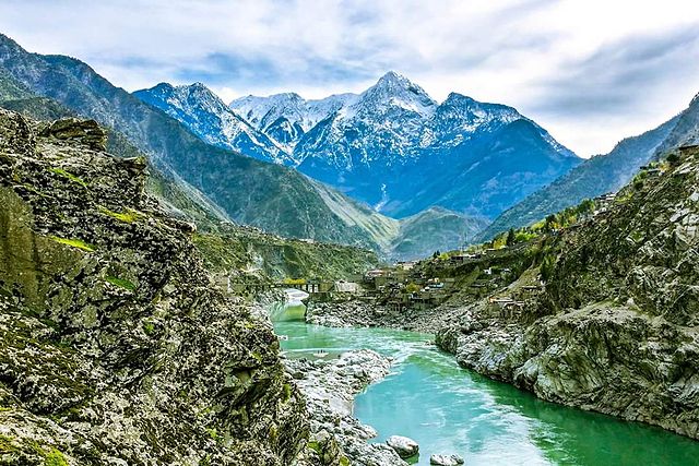
Indus or Abaseen Kohistan is a distant district of Pakistan’s province Khyber Pakhtunkhawa (KPK). It is stretching over 34.40 to 30.35 longitude and 50.2 to 75.30 latitude. The district of Kohistan has an area of 7581 square kilometers.
Greek historians Herodotus and Ptolemy named Kohistani areas “Diokaie”. Naran Valley, Andrak, Chor’s mountains, Swat Valley, Nanga Parbat’s area Chilas, Tangir, and Darel set its natural boundary. The climate in the upper and central areas of Kohistan is pleasant in summer and extremely cold in winter.
There is heavy snowfall in the upper regions. The temperature here is below the freezing point. The lower areas that are near the River Indus are too hot and cold in summer and winter respectively. Jalkot, Harban, Palis, Pattan, Khandiya, and Dabir are central areas.
Details of District Indus Kohistan – KPK
| Attribute | Details |
|---|---|
| Name | District Indus Kohistan |
| Province | Khyber Pakhtunkhwa (KPK), Pakistan |
| Region | Northern Pakistan |
| Headquarters | Pattan |
| Location | Northern areas of KPK |
| Geography | Mountainous with the Indus River running through |
| Elevation | Varies, with some areas exceeding 6,000 meters |
| Population | Approximately 200,000 (as of last available data) |
| Official Language | Pashto, Hindko, and other regional languages |
| Time Zone | Pakistan Standard Time (UTC+5) |
| Climate | Cold and temperate, with heavy snowfall in winter |
| Major Religion | Islam (predominantly Sunni) |
| Economy | Primarily based on agriculture and livestock |
| Tourist Attractions | – Natural beauty, rivers, and valleys |
| Transportation | Limited road network, no airports |
| Notable Features | – Rich cultural heritage – Scenic landscapes |
| Educational Institutes | Limited educational institutions in the district |
| Hospitals | Basic healthcare facilities in major towns |
| Restaurants | Local eateries serving traditional cuisine |
| Local Dishes | Local cuisine with a focus on lamb and rice |
| Languages | Pashto, Hindko, Shina, and other regional dialects |
| Cultural Festivals | Local festivals reflecting Pashtun culture |
| Local Crafts | Traditional handicrafts and textiles |
Sites near Indus Kohistan
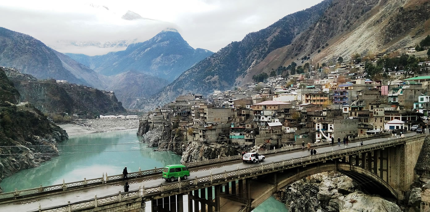
1- Pattan
The river Indus confluence with the river Chowadara and Palas in this fertile area which is 42km from Basham. One can reach Dabir, Kial Valley, Basham, and Komala via Pattan. There is an inscription in the memory of martyrs near the Petrol Pump. Please pray for the souls who sacrificed their lives for our future.
2- Dasu-Komala
Pattan is 36km forward to Komala. Two cities connect Karakoram Highway (Silk Route) between Basham and Chilas. In them, district Dasu is the central headquarter of Kohistan. There are government offices and rest houses. While Komala is the trade center. The river and mountains turn themselves from Dasu.
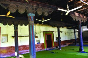
3- Seo Mosque
This mosque is located in Seo Village near the district capital Dasu. This 250-year-old historical mosque is constructed with wood pillars and beams. The beauty of the mosque is enhanced by engraving beautiful designs on the wood. It is a place of cultural representation in the district of Dasu. Its best trail is from Komala.

4- Shitial
Beyond Sazin, there are statements in Logrian, Kharoshti, and Barahmen languages inscribed on various stones. These statements belong from the third to the seventh A.D. and before Christ. Some places have engravings of wild animals, Hunn, Sogairin, Moon Idol, and Buddha Stupa.
You will have to cross the bridge on the left side of the river to see the pictures that are 1000 to 5000 years old before Christ. You can also buy local handicrafts from a nearby village.
5- Darel Valley
This beautiful Valley is 82km northwest of Chilas Valley. A jeep track from Shitial Bridge will take you to Darel Valley. It is the administrative headquarter of Gumary Valley.
It is the biggest center of archaeological remains and therefore the archaeological department is there too. Manikal is its central area. The signs of Buddha University are a few distances from Mazot. Mahatma Buddha pictures are carved on large heavy stones.
There are archaeological traces in the Sonikot and Lolokot too. Gomaray has ancient traces and the rest houses. Chinese Tourists Faseen (430) and Yaun Xeng (630) have visited Darel Valley. One can book a PWD rest house from Chilas and Gilgit.
6- Harban
There are the names of Buddha Monks on the stones near Harban and in Menargah, Thor, Hod, and Getch on both sides of Karakoram Highway.
FAQs
1. Where is District Indus Kohistan located in Pakistan?
District Indus Kohistan is situated in the Khyber Pakhtunkhwa (KPK) province in the northern areas of Pakistan.
2. What is the geography of Indus Kohistan?
The district is characterized by mountainous terrain and is traversed by the Indus River, which adds to its picturesque natural beauty.
3. What is the population of District Indus Kohistan?
The district had an approximate population of 200,000 residents.
4. What are the major languages spoken in Indus Kohistan?
The primary languages are Pashto and Hindko, with regional dialects like Shina also being spoken by some communities.
5. Are there any notable tourist attractions in Indus Kohistan?
While not a major tourist destination, Indus Kohistan offers natural beauty, serene rivers, valleys, and breathtaking landscapes for those seeking a quieter, off-the-beaten-path experience.
6. What is the climate like in the district?
The region experiences a cold and temperate climate with heavy snowfall during the winter months, making it particularly challenging to access in those times.
7. Are there educational institutions and healthcare facilities in Indus Kohistan?
Educational institutions are limited in the district, and basic healthcare facilities can be found in major towns. However, it’s important to be aware of the limited resources available.
8. What are the local dishes or cuisine specialties in Indus Kohistan?
The cuisine in Indus Kohistan typically features dishes with a focus on lamb and rice, reflecting the local culinary traditions.
9. Can tourists explore the cultural heritage of Indus Kohistan?
Yes, the district has a rich cultural heritage, and you can experience local festivals and traditions that reflect the Pashtun culture.
10. How can one reach Indus Kohistan, and is it easily accessible?
The district has a limited road network, and there are no airports. Traveling to Indus Kohistan can be a bit challenging, and it’s advisable to plan your journey accordingly.
Wind Up Lines
Khyber Pakhtunkhwa is enriched with historical sites, ancient archaeological remains, splendid landmarks, and high mountains. Indus Kohistan is one of the historical towns of KPK. Dasu, Komala, Darel Valley and Seo Mosque, are beautiful historical spots.